welcome to our earthquakes page!
on this page you will learn about the forces in earth's crust, earthquakes and seismic waves, monitoring earthquakes, and earthquake safety.
Forces in earth's crust
Stress in the earth's crustBy: Taylor L.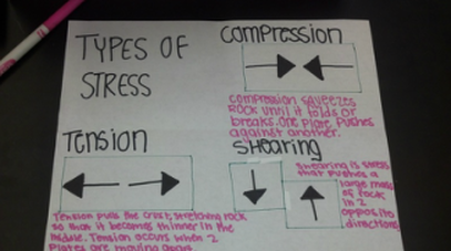
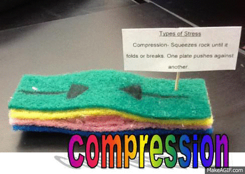
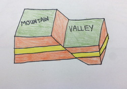
The different types of stress are tension, compression, and shearing. These things work together and takes over millions or years to change the shape and volume of rock. Most changes in the crust change so slowly that it cannot be observed directly. But, if you speed up time, you could see the crust bend, stretch, tilt, or slide. The slow shift of the Earth's crust cause these changes. Tension pull the crust, stretching rock so that it becomes thinner in the middle. An example would be pulling apart a piece of warm bubble gum. Compression squeezes the rick until it fold or breaks. The two plates compress like a giant trash compactor. Shearing push a large mass of rock in two opposite directions. It can cause rock to break and slip apart.
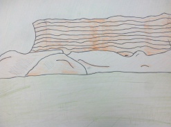
The Location of Faults
|
Types of Stress Models
|
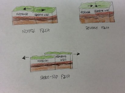
Normal faults
|
Reverse fault
|
Strike-slip fault
|
land features
|
Uplifting Earth's crust
|
Earthquakes and seismic waves
Seismic Waves Animation ~ Raelynn |
Different Scales slide show ~Samantha |
Mercali Scale -JenMercali Scale is a scale that developed to rate earthquakes according to the level of damage at a given place. One earthquake can have different Mercali ratings if it causes different amounts of ground motion at different locations.
|
Richter Scale -JenA Richter Scale is a rating of an earthquake's magnitude based on the size of its seismic waves. Seismic waves are measured by a seismograph. It provides accurate measurements ONLY for small earthquakes that are nearby.
|
moment magnitude scale -JenMoment Magnitude Scale estimates total energy released by earthquakes. It rates earthquakes of all sizes, near or far. Today, geologists have been using this more than the Richter Scale.
|
How to find the epicenter animation
By Cassidy and Taryn
Geologists use seismic waves to locate an earthquake epicenter. P waves arrive at a seismograph first, with S waves following behind. Scientists measure the difference between the arrival times of the P and S waves. The farther away the earthquake is, the greater the time between the arrival of P and S waves. Then, they draw at least three circles using data from different seismographs all over the world. The center of each circle is the seismograph’s location, while the radius is the distance from that seismograph to the epicenter. The point where the three circles intersect is the location of the epicenter.
Paragraph ~ Taryn
Paragraph ~ Taryn
earthquake safety
SAFETY - SOMETHING THAT NOT ALL OF US MAY BE ABLE TO AFFORD ~ WRITTEN BY: KIANA
Better Safe than Sorry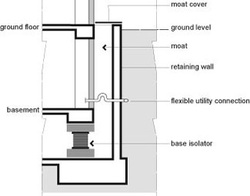
A seismic safe building is a building that have items added to them that try to reduce earthquake damage. Somethings reinforce the building while others allow the building to move. In areas that often have earthquakes, like on the edges of plate or near volcanoes, tall buildings may have one or more of the things listed on the side of this article.
Seismic safe buildings are designed to save lives and reduce damage that may occur during an earthquake, or other natural disasters. Although these are some pretty amazing advances in technology, it still has its problems. For example, its hard to install base isolators in an old building, because they go under ground. However, there are also some really simple things that you can do to make your own house a little safer during a quake. You can fasten bookshelves, cabinets, and dressers to wall studs. Secure brick chimneys with metal brackets and nail plywood around the chimney. Another thing you can do is remove heavy items from walls above beds, and position beds away from windows. Therefore, if an earthquake does occur while you are sleeping, you will have a lower chance of things falling on you. |
TerminologyI. Cross Braces – Steel braces that are placed between stories to stiffen a buildings frame and absorb energy during an earthquake.
II. Dampers – Work like shock absorbers in a car to absorb some of the energy of seismic waves. III. Flexible Pipes – Pipes that bend as energy passes through them. IV. Shear Walls – Transfers some of a quakes energy from roofs and floors to the buildings foundation. V. Tension Ties – These devices “tie” the floor and ceiling of a building to the walls. They absorb and scatter earthquake energy and thus reduce damage. VI. Base Isolators – Pads that separate , or isolate, a building from its foundation and prevent some of an earthquakes energy from entering the building VII. Cripple Wall - In a wood-frame house, the section of wall under the house between the concrete foundation and the floor joists. |
Aftershocks ~ WRITTEN BY: ALANA Practicing the proper ways of Drop, Cover, and Hold
When a major earthquake strikes, it can cause a severe amount of damage. This type of damage includes aftershocks, tsunamis, liquefaction, and shaking. The one type of damage that occurs the most would be aftershocks. Aftershocks are mini earthquakes that occur after the major earthquake. An aftershock may strike hours, days, or possibly even months after the earthquake. Sometimes, buildings weakened by an earthquake collapse during an aftershock. VIDEO: KAYSEY SIOBAL |
|
Monitoring Earthquakes
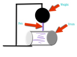
HOW DO SEISMOGRAPHS WORK?
|
|
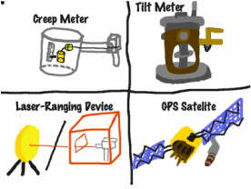
how do geologists monitor faults?
Monitoring Faults
|
Monitoring Faults
|
HOW ARE SEISMOGRAPHIC DATA USED?
By: Krista
Seismographic data is used in three different ways: mapping faults, detecting changes along faults, and trying to predict earthquakes. Mapping faults can be hard because most faults are hidden under a layer of deep soil or rock. To find faults that are hidden under soil or rock, they use seismographs. Seismographs detect the seismic waves that reflect off of faults and record its findings. By knowing this geologists then know where and how deep the fault is. Finding the locations of hidden faults help scientists figure out where there are greater risks of an earthquake. The size of an earthquake is determined by the amount of friction there is. Friction is the force that resists the movement of one surface as it move across another. Friction happens because all surfaces are not smooth. Their can be different levels of friction low, moderate, and high. Low friction causes the rocks of a fault to pass each other almost smoothly so that their will not be and big earthquakes. Moderate friction causes the fault sides to smash together and jerk free from time to time. This will create a small earthquake. High friction will latch the rocks of the fault together causing a lot of stress, creating a large earthquake. Scientist still can not predict when an earthquake will exactly occur even with reliable resources. Stress along a fault will normally create and earthquake, but some times and earthquake will fail to occur. Sometimes more than one earthquake can relieve stress along a fault. This is why scientist still can’t determine when exactly an earthquake will occur.ye
How Earthquakes Affect Our Lives
How do earthquake's affect our lives?
|
How do earthquakes affect our lives?by: megan
One of the ways earthquakes affect our lives is by damaging the buildings, bridges, roads, and houses around us. The shaking of an earthquake can also cause utility poles and underground water and gas pipes to break. The amount of damage caused depends on the magnitude of the earthquake. Some earthquakes only affect our lives a little, but others can cause great devastation. Earthquakes can also harm friends, family, and strangers around you. People can get hit or trapped when buildings fall. Earthquakes can also harm people who are not near you too. Some earthquakes will cause huge tsunamis to wash over places around where the earthquake hit. Overall, earthquakes, big or small, affect people’s lives in many different ways.
|
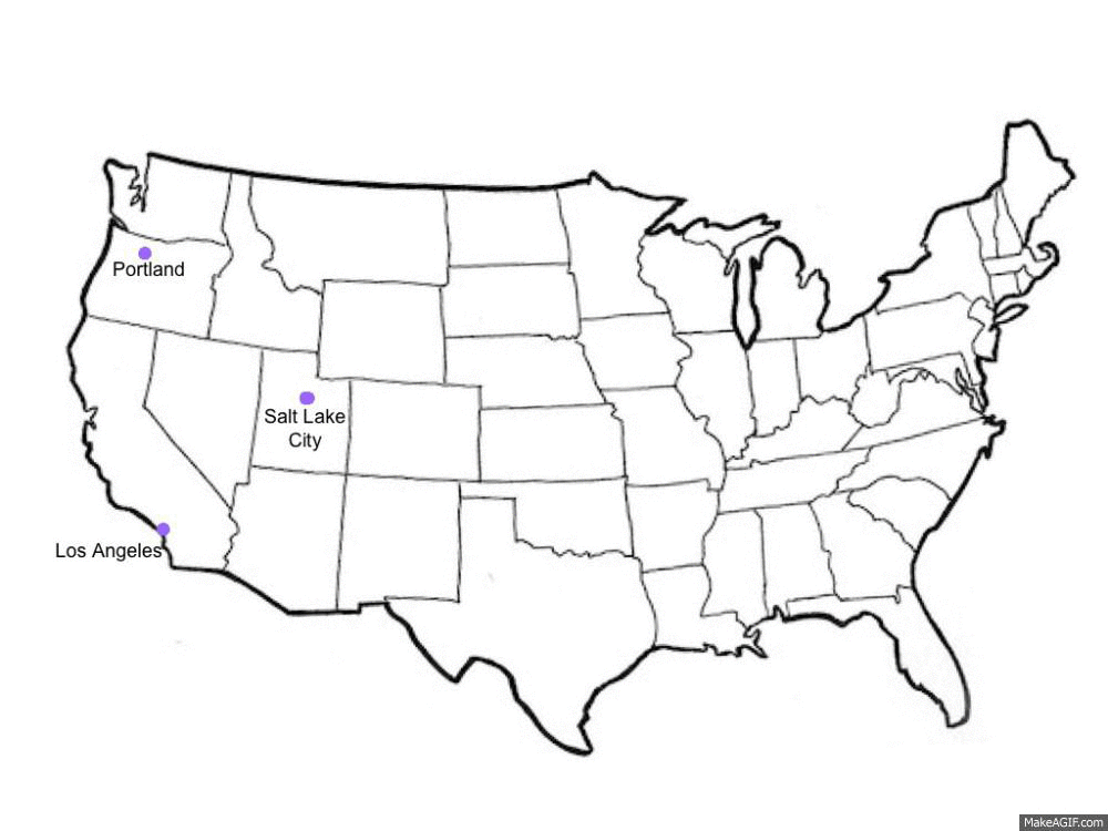
New Zealand Earthquake
BY: TAYLOR Y.
Earthquakes affect our lives because it causes us to lose our houses, money, jobs, loved ones, and many more. Earthquakes can cause cracks in the ground, fires, and buildings to fall over or break apart. The earthquake in New Zealand happened on September 4, 2010. The magnitude of this earthquake was 7.0 using the Richter scale. There was an aftershock of 5.7 magnitude, 20 minutes later.
To learn more about the New Zealand earthquake, on the left is a video of the damage it caused. On the right is a map of where the location of the earthquake was.
|
|
